Showing posts with label mountain. Show all posts

Tuesday, November 26, 2013

Colours of Jiuzhaigou


Long Lake
Jiuzhaigou Valley (simplified Chinese: 九寨沟; traditional Chinese: 九寨溝; pinyin: Jiǔzhàigōu; literally "Valley of Nine Villages"; Tibetan: གཟི་རྩ་སྡེ་དགུ།, Wylie: gzi-rtsa sde-dgu, ZYPY: Sirza Degu) is a nature reserve and national park located in the north of Sichuan, China. 
Jiuzhaigou Valley is part of the Min Mountains on the edge of the Tibetan Plateau and stretches over 72,000 hectares (180,000 acres). It is known for its many multi-level waterfalls, colorful lakes, and snow-capped peaks. Its elevation ranges from 2,000 to 4,500 metres (6,600 to 14,800 ft). 
Jiuzhaigou Valley was inscribed by UNESCO as a World Heritage Site in 1992 and a World Biosphere Reserve in 1997. It belongs to the category V (Protected Landscape) in the IUCN system of protected area categorisation.


Location of Jiuzhaigou Valley

Long Lake

Long Lake


Tiger Lake

Five Flower Lake

Close to Five Coloured Pool

Tiger Lake

History
Jiuzhaigou (literally "Nine Village Valley") takes its name from the nine Tibetan villages along its length. The remote region was inhabited by various Tibetan and Qiang peoples for centuries. Until 1975 this inaccessible area was little known. Extensive logging took place until 1979, when the Chinese government banned such activity and made the area a national park in 1982. An Administration Bureau was established and the site officially opened to tourism in 1984; layout of facilities and regulations were completed in 1987.
The site was inscribed by UNESCO as a World Heritage Site in 1992 and a World Biosphere Reserve in 1997. The tourism area is classified as a AAAAA scenic area by the China National Tourism Administration.
Since opening, tourist activity has increased every year: from 5,000 in 1984 to 170,000 in 1991, 160,000 in 1995, to 200,000 in 1997, including about 3,000 foreigners. Visitors numbered 1,190,000 in 2002.[4] As of 2004, the site averages 7,000 visits per day, with a quota of 12,000 being reportedly enforced during high season. The Town of Zhangzha at the exit of the valley and the nearby Songpan County feature an ever-increasing number of hotels, including several luxury five-stars, such as Sheraton.
Developments related to mass tourism in the region have caused concerns about the impact on the environment around the park.

Tiger Lake

Tiger Lake

Tiger Lake

Tiger Lake

Population
Seven of the nine Tibetan villages are still populated today. The main agglomerations that are readily accessible to tourists are Heye, Shuzheng and Zechawa along the main paths that cater to tourists, selling various handicrafts, souvenirs and snacks. There is also Rexi in the smaller Zaru Valley and behind Heye village are Jianpan, Panya and Yana villages. Guodu and Hejiao villages are no longer populated.
Penbu, Panxing and Yongzhu villages lie along the road that passes through the town of Jiuzhaigou/Zhangza outside the valley.
In 2003, the permanent population of the valley was about 1,000 comprising 112 families, and due to the protected nature of the park, agriculture is no longer permitted so the locals now rely on tourism and local government subsidies to make a living.

Tiger Lake

Tiger Lake

Tiger Lake

Tiger Lake

Geography & Climate
Jiuzhaigou lies at the southern end of the Minshan mountain range, 330 km (205 mi) north of the provincial capital of Chengdu. It is part of the Jiuzhaigou County (formerly Nanping County) in the Aba Tibetan Qiang Autonomous Prefecture of northwestern Sichuan province, near the Gansu border.
The valley covers 720 km2 (278 sq mi), with buffer zones covering an additional 600 km2 (232 sq mi). Its elevation, depending on the area considered, ranges from 1,998 to 2,140 m (at the mouth of Shuzheng Gully) to 4,558-4,764 m (on Mount Ganzigonggai at the top of Zechawa Gully).
The climate is subtropical to temperate monsoon with a mean annual temperature of 7.8 °C, with means of -3.7 °C in January and 16.8 °C in July. Total annual rainfall is 761 mm but in the cloud forest it is at least 1,000 mm. 80% of rainfall occurs between May and October.

Tiger Lake

Tiger Lake

Close to Resting Dragon Lake

Sparkling Lake

Ecology
Jiuzhaigou's ecosystem is classified as temperate broad-leaf forest and woodlands, with mixed mountain and highland systems. Nearly 300 km2 (116 sq mi) of the core scenic area are covered by virgin mixed forests. Those forests take on attractive yellow, orange and red hues in the autumn, making that season a popular one for visitors. They are home to a number of plant species of interest, such as endemic varieties of rhododendron and bamboo.
Local fauna includes the endangered giant panda and golden snub-nosed monkey. Both populations are very small (less than 20 individuals for the pandas) and isolated. Their survival is in question in a valley subject to increasing tourism. Jiuzhaigou is also home to approximately 140 bird species.

Sparkling Lake

Arrow Bamboo Lake

Five Flower Lake

Five Flower Lake

Geology and hydrology
Jiuzhaigou's landscape is made up of high-altitude karsts shaped by glacial, hydrological and tectonic activity. It lies on major faultlines on the diverging belt between the Qinghai-Tibet Plate and the Yangtze Plate, and earthquakes have also shaped the landscape. The rock strata is mostly made up of carbonate rocks such dolomite and tufa, as well as some sandstone and shales.
The valley includes the catchment area of three gullies (which due to their large size are often called valleys themselves), and is one of the sources of the Jialing River, part of the Yangtze River system.
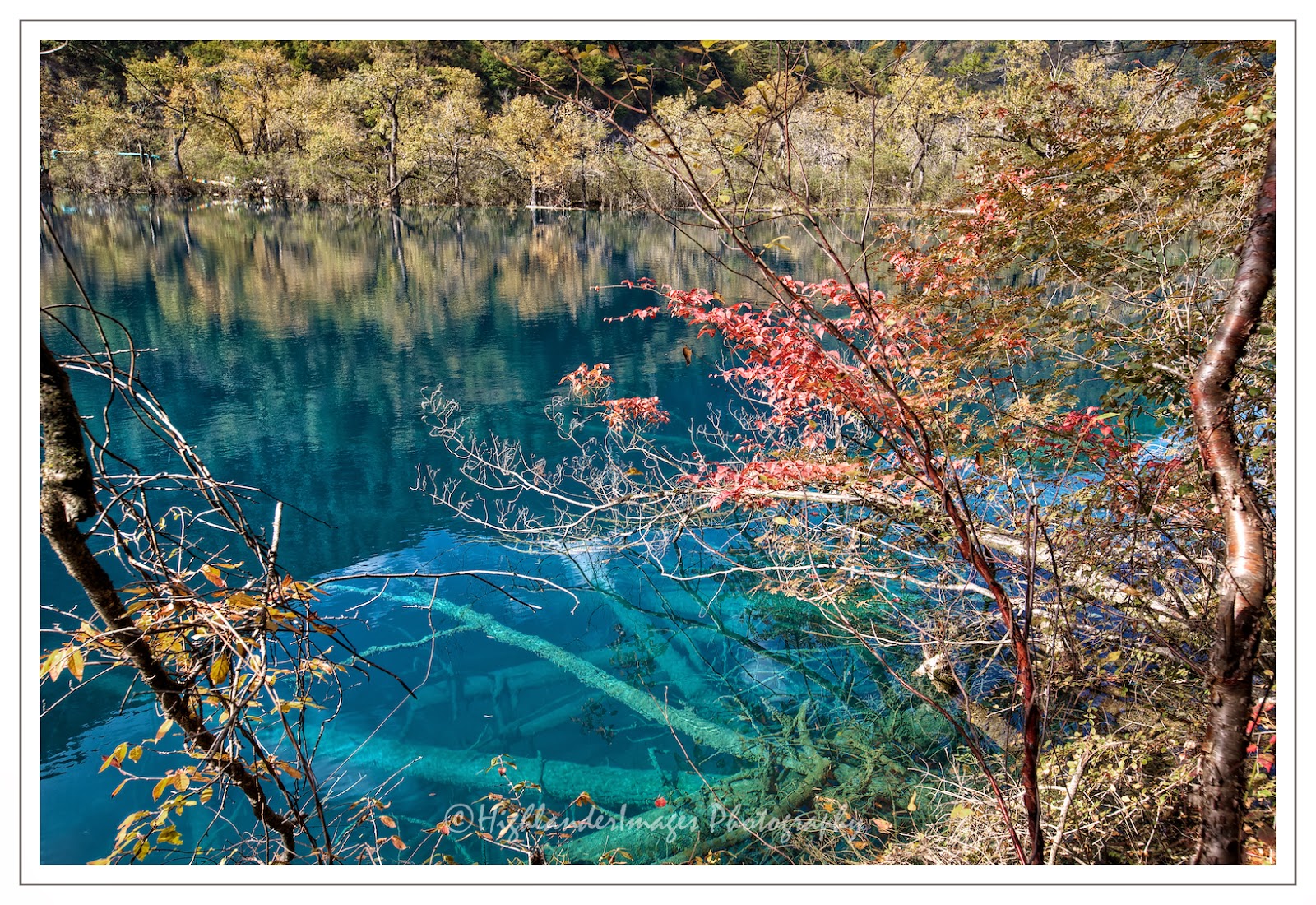
Jiuzhaigou's best-known feature is its dozens of blue, green and turquoise-colored lakes. The local Tibetan people call them "Haizi" in Chinese, meaning "son of the sea". Originating in glacial activity, they were dammed by rockfalls and other natural phenomena, then solidified by processes of carbonate deposition. Some lakes have a high concentration of calcium carbonate, and their water is very clear so that the bottom is often visible even at high depths. The lakes vary in color and aspect according to their depths, residues, and surroundings.

Some of the less stable dams and formations have been artificially reinforced, and direct contact with the lakes or other features is forbidden to tourists.

Five Flower Lake

Five Flower Lake

Five Flower Lake

Five Flower Lake


Sunday, February 17, 2013

Prasat Preah Vihear


Away from the normal tourist temple areas of Angkor you can find some unique and incredibly interesting  remote temples in Cambodia which are uncluttered by tourists allowing you to feel like a real first-time explorer. One such temple, and one which is one of the more remote locations, is Prasat Preah Vihear. Preah Vihear Temple is a Hindu temple built during the reign of Khmer Empire, that is situated on top of a 525-metre (1,722 ft) cliff in the Dangrek Mountains, in the Preah Vihear province, Cambodia. In 1962, following a lengthy dispute between Thailand and Cambodia over ownership, the International Court of Justice (ICJ) in The Hague awarded the temple to Cambodia. Because of these past disputes there is still a heavy military presence at the temple site with bunkers, dugouts and many soldiers on the hilltop.


Prasat Preah Vihear has the most spectacular setting of all the temples built during the six-centuries-long Khmer Empire with a view for many miles over the plains of North Cambodia. As a key edifice of the empire's spiritual life, it was supported and modified by successive kings and so bears elements of several architectural styles. Preah Vihear is unusual among Khmer temples in being constructed along a long north-south axis, rather than having the conventional rectangular plan with orientation toward the east. The temple gives its name to Cambodia's Preah Vihear province, in which it is now located, as well as the Khao Phra Wihan National Park which borders it in Thailand's Sisaket province and through which the temple is most easily accessible. On July 7, 2008, Preah Vihear was listed as a UNESCO World Heritage Site.


The temple was built at the top of Pey Tadi, a steep cliff in the range of the Dangrek Mountains which are the natural border between Thailand and Cambodia. Hence, the temple is located exactly at the watershed border line between Thailand and Cambodia. The ancient entrance passage and stairs to the temple was built from Thailand's highland side of the mountain up to the cliff, NOT from Cambodia's very low plain side. Hundred years ago, Cambodia was a part of Thailand (known as Kingdom of Siam) until France colonization period before World War 1. Following that period, the Colonial Cambodia and Thailand both declared the occupation of the temple site.


The Temple was listed by Thailand as being in Bhumsrol village of Bueng Malu sub-district (now merged with Sao Thong Chai sub-district), in Kantharalak district of the Sisaket province of eastern Thailand. It is 110 km from the Mueang Si Sa Ket district, the center of Si Sa Ket province.
The Temple was also listed by Cambodia as being in Svay Chrum Village, Kan Tout Commune, in Choam Khsant District of Preah Vihear province of northern Cambodia. The temple is 140 km from Angkor Wat and 320 km from Phnom Penh.
After the ICJ ruled in 1962 that only the Temple building belonged to Cambodia. While the direct way to access the temple is always from Thailand. This verdict has given hard time to both countries ever since.
Construction of the first temple on the site began in the early 9th century; both then and in the following centuries it was dedicated to the Hindu god Shiva in his manifestations as the mountain gods Sikharesvara and Bhadresvara. The earliest surviving parts of the temple, however, date from the Koh Ker period in the early 10th century, when the empire's capital was at the city of that name. Today, elements of the Banteay Srei style of the late 10th century can be seen, but most of the temple was constructed during the reigns of the Khmer kings Suryavarman I (1002–1050) and Suryavarman II (1113–1150). An inscription found at the temple provides a detailed account of Suryavarman II studying sacred rituals, celebrating religious festivals and making gifts, including white parasols, golden bowls and  elephants to his spiritual advisor, the aged Brahmin Divakarapandita. The Brahmin himself took an interest in the temple, according to the inscription, donating to it a golden statue of a dancing Shiva known as "Nataraja". In the wake of the decline of  Hinduism in the region the site was converted to use by Buddhists.


The temple complex runs 800 m (2,600 ft) along a north-south axis facing the plains to the north, from which it is now cut off by the international border. It consists essentially of a causeway and steps rising up the hill towards the sanctuary, which sits on the clifftop at the southern end of the complex (120 m/390 ft above the northern end of the complex, 525 m/1,722 ft above the Cambodian plain and 625 m/2,051 ft above sea level). Although this structure is very different from the temple mountains found at Angkor, it serves the same purpose as a stylised representation of Mount Meru, the home of the gods.
The approach to the sanctuary is punctuated by five gopuras (these are conventionally numbered from the sanctuary outwards, so gopura five is the first to be reached by visitors). Each of the gopuras before the courtyards is reached by a set of steps, and so marks a change in height which increases their impact. The gopuras also block a visitor's view of the next part of the temple until they pass through the gateway, making it impossible to see the complex as a whole from any one point.
The fifth gopura, in the Koh Ker style, retains traces of the red paint with which it was once decorated, although the tiled roof has now disappeared. The fourth gopura is later, from the Khleang/Baphuon periods, and has on its southern outer  pediment, "one of the masterpieces of Preah Vihear" (Freeman, p. 162) : a depiction of the Churning of the Sea of Milk. The third is the largest, and is also flanked by two halls. The sanctuary is reached via two successive courtyards, in the outer of which are two libraries.


On July 8, 2008, the World Heritage Committee decided to add Prasat Preah Vihear, along with 26 other sites, to the World Heritage Site list, despite several protests from Thailand, since the map implied Cambodian ownership of disputed land next to the temple.
As the process of Heritage-listing began, Cambodia announced its intention to apply for World Heritage inscription by UNESCO. Thailand protested that it should be a joint-effort and UNESCO deferred debate at its 2007 meeting.
Following this, both Cambodia and Thailand were in full agreement that Preah Vihear Temple had "Outstanding Universal Value" and should be inscribed on the World heritage List as soon as possible. The two nations agreed that Cambodia should propose the site for formal inscription on the World Heritage List at the 32nd session of the World Heritage Committee in 2008 with the active support of Thailand. This led to a redrawing of the map of the area for proposed inscription, leaving only the temple and its immediate environs.
However, Thailand's political opposition launched an attack on this revised plan  claiming the inclusion of Preah Vihear could nevertheless "consume" the overlapping disputed area near the temple. In response to the political pressure at home, the Thai government withdrew its formal support for the listing of Preah Vihear Temple as a World Heritage site.
Cambodia continued with the application for World Heritage status and, despite official Thai protests, on July 7, 2008, Preah Vihear Temple was inscribed on the list of World Heritage sites.


The renewed national boundary dispute since 2008 has been a reminder that despite the World Heritage ideals of conservation for all humanity, operating a World Heritage site often requires use of national authority at odds with the local cultures and natural diversity of the landscape. Prior to the listing, Cambodia considered Preah Vihear to be part of a Protected Landscape (IUCN category V), defined as "Nationally significant natural and semi-natural landscapes which must be maintained to provide opportunities for recreation." However, Category V is generally defined as "Land, with coast and seas as appropriate, where the interaction of people and nature over time has produced an area of distinct character with significant aesthetic, cultural and/or ecological value, and often with high biological diversity. Safeguarding the integrity of this traditional interaction is vital to the protection, maintenance and evolution of such an area."