Showing posts with label lake. Show all posts
Monday, September 10, 2012
Floating Lake Life in Cambodia
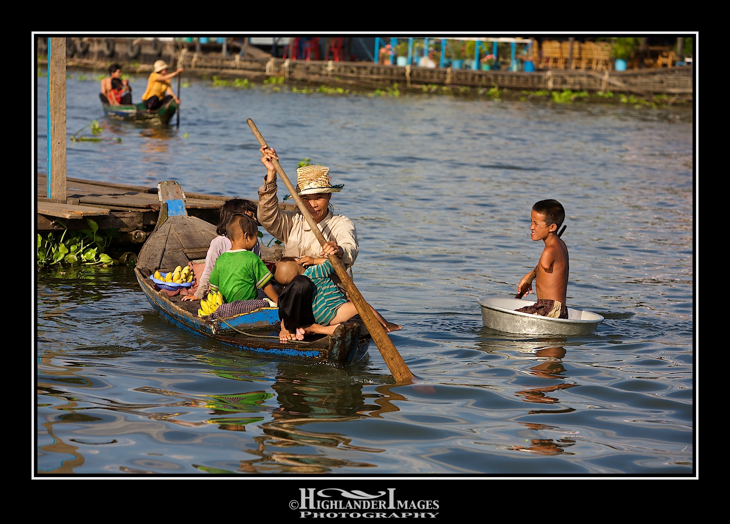
Lake Tonlé Sap in Cambodia is the largest freshwater lake in South East Asia and is an ecological hot spot that was designated as a UNESCO biosphere in 1997. The lake is situated almost in the geographical centre of Cambodia, is home to around 25% of Cambodia's population and plays an indispensable role in Cambodian life. This human population live in and around the water both in stilted villages on the banks and on floating villages on the lake itself. In addition to this human population the lake is home to more than 200 species of fish and a variety of animal species including exotic birds.
The Tonlé Sap is unusual for two reasons: its flow changes direction twice a year, and the portion that forms the lake expands and shrinks dramatically with the seasons. From November to May, Cambodia's dry season, the Tonlé Sap is fairly small, around 1 metre deep, with an area of 2,700 square km and drains into the Mekong River at Phnom Penh. However, when the year's monsoon rains begin in June, the flow of water reverses and Tonlé Sap backs up to form an enormous lake of around 16,000 square km with depths of around 9 metres.
As the waters of the lake rise, Cambodian communities living in stilted villages such as Kompong Phluk move higher and higher up their uniquely designed homes to stay above the water line, while those living in floating homes, including Chong Kneas and Kompong Luong, simply relocate according to the seasonal ebb and flow.
The pulsing system with its large floodplain, rich biodiversity, and high annual sediment and nutrient fluxes from Mekong makes the Tonlé Sap one of the most productive inland fisheries in the world, supporting over three million people and providing over 75% of Cambodia's annual inland fish catch and 60% of Cambodians' protein intake. As this cycle is so vital to the livelihoods of many Cambodians, the nation celebrates the reversal of the river with a grand water festival, the Bonn Om Tuk, during which people from all over Cambodia converge in Phnom Penh for exciting boat races!
Labels:
biodiversity,
biosphere,
bird,
Cambodia,
dry season,
ecology,
fish,
floating,
floodplain,
freshwater,
lake,
Mekong,
monsoon,
Phnom Penh,
river,
stilted,
Tonle Sap,
UNESCO,
village,
wet season
Saturday, June 23, 2012
The Long & Winding Road to The Lakes
This is the undulating and winding road from that runs down from the Kirkstone Pass to Ambleside in the Lake District.
The Lake District, or The Lakes, is a mountainous region in Cumbria, North West England and is a popular holiday destination in UK. The majority of the area was designated as the Lake District National Park in 1951. It is the largest of the thirteen National Parks in England and Wales, and the second largest in the UK (after the Cairngorms). It lies entirely within the modern county of Cumbria, shared historically by the counties of Cumberland, Westmorland and Lancashire. All the land in England higher than three thousand feet above sea level lies within the National Park, including Scafell Pike, the highest mountain in England. It also contains the deepest and longest lakes in England, Wastwater and Windermere, respectively.
Thirlmere
Only one of the lakes in the Lake District is called by that name, Bassenthwaite Lake. All the others such as Windermere, Coniston Water, Ullswater and Buttermere are meres, tarns and waters, with mere being the least common and water being the most common. The major lakes and reservoirs in the National Park are given below.
- Bassenthwaite Lake
- Brotherswater
- Buttermere
- Coniston Water
- Crummock Water
- Derwent Water
- Devoke Water
- Elter Water
- Ennerdale Water
- Esthwaite Water
- Grasmere
- Haweswater Reservoir
- Hayeswater
- Loweswater
- Rydal Water
- Thirlmere
- Ullswater
- Wast Water
- Windermere
Buttermere
Conniston Water
Steamer on Ullswater
Windermere
Labels:
Ambleside,
Buttermere,
Conniston,
Cumbria,
England,
lake,
Lake District,
lakes,
mere,
National Park,
Thirlmere,
Ullswater,
water,
Windermere
Saturday, November 26, 2011
Kapellbrücke
The Chapel Bridge (German: Kapellbrücke) is a covered wooden footbridge spanning diagonally across the Reuss River in the city of Lucerne in central Switzerland. Named after the nearby St. Peter's Chapel, the bridge is unique since it contains a number of interior paintings dating back to the 17th century, although many of them were destroyed along with most of the centuries old bridge in a 1993 fire. Subsequently restored, the Kapellbrücke is the oldest wooden covered bridge in Europe, as well as the world's oldest surviving truss bridge. It serves as the city's symbol and as one of Switzerland's main tourist attractions.
Lucerne is a city in north-central Switzerland, in the German-speaking portion of that country. Lucerne is the capital of the Canton of Lucerne and the capital of the district of the same name. With a population of about 76,200 people, Lucerne is the most populous city in Central Switzerland, and a nexus of transportation, telecommunications, and government of this region. The city's metropolitan area consists of 17 cities and towns located in three different cantons with an overall population of about 250,000 people.
Due to its location on the shore of Lake Lucerne (der Vierwaldstättersee), within sight of Mount Pilatus and Rigi in the Swiss Alps, Lucerne has long been a destination for tourists. One of the city's famous landmarks is the Chapel Bridge (Kapellbrücke), a wooden bridge first erected in the 14th century. Lucerne was voted the fifth most popular tourism destination in the world in 2010 by Tripadvisor.
Labels:
Alps,
Chapel Bridge,
Europe,
German,
Kapellbrücke,
lake,
Lake Lucerne,
Reuss River,
Switzerland,
tourist,
wooden
Friday, November 11, 2011
KLCC Park
Today's i-phone image of KLCC Park is taken from the mid level (Floor 41) of Petronas Twin Towers, Kuala Lumpur, Malaysia on a rather cloudy and hazy day. The park was designed by Roberto Burle Marx. It is said that it was the last work undertaken by the Brazilian architect. When the park was designed, the aim was to "leave the world a little more sensitive and a little more educated to the importance of nature".
The park was designed to showcase a heritage of tropical greenery by integrating man's creation with nature. The park itself contrasts as a calm environment in the midst of the hustle and bustle of the city. The park features many combinations of man-made design such as cements, water features and also natural features such as trees, shrubs, stones and wood. Elements of shape and topography were created to give an illusion of space. The combination of trees, shrubs and sculptures were arranged to provide color and form to the park.
Conservation and bio-diversity was a major influence in the creation of the park. 23 of the mature and rarer specimens were saved from the old Selangor Turf Club and transplanted into the park grounds. 1900 indigenous trees and 66 species of palms were planted in the park to promote bio-diversity. The trees were deliberately selected to attract local and migratory birds.
A man made lake was built in the middle of the park, directly in front of Suria KLCC mall and Petronas Twin Towers towards the middle of the park. A 43 meter elevated bridge that cut across the lake provides a vantage view of the park and the twin towers.
Labels:
Central Park,
horse,
iPhone,
KLCC,
Kuala Lumpur,
lake,
Malaysia,
Petronas Towers,
racing,
Roberto Burle Max,
Selangor Turf Club,
Suria
Saturday, August 06, 2011
The Lake, Central Park, NYC
The Central Park Lake, in conjunction with the Ramble, creates an essential part of the "Greensward" design plan created by Frederick Law Olmsted and Calvert Vaux when designing the initial features of what would become Central Park.
What is now a stunning and picturesque 18-acre lake was once nothing more than a large, untamed swamp. After its excavation in 1857, the Lake was opened for its first winter of ice-skating in 1858. Until 1950, the Lake was used for ice-skating during the winter months and boating in the summer. After 1950, however, the skating rink was officially closed, allowing the Lake's former wildlife inhabitants to take up residence there once more. As such, the Lake is now an excellent location for bird watching, where one can spot swans, ducks, and even the occasional egret or heron.
The second largest man-made body of water in the Park, the Lake provides wonderful opportunities for viewing its abundant flora and fauna from rowboats, which are available for rent during the spring and summer months at the Loeb Boathouse. Aside from taking a boat, other options for nature sightseeing include taking a Venetian-style gondola ride around the Lake, or simply walking along the shore.
Like many other Park attractions, the Lake was also restored by the Central Park Conservancy. It was reopened to visitors in 2008. The Lake is a sight not to be missed if you're in the mood for a calming boat ride through bamboo patches, bridges, and natural splendor in the Park.
Labels:
boating,
Central Park,
lake,
leisure,
Manhattan,
New York City,
ramble
Monday, March 07, 2011
The Last Bridge
As I walked around the West Lake in Hangzhou, China in the early morning mist this beautiful arched bridge blended in with the mist over the lake giving it the appearance of being the very last bridge. Again timing in photography is key and I waited some time till I captured a figure on the bridge to give it a sense of scale.
Monday, February 14, 2011
Danau Batur
Lake Batur or Danau Batur is a crater lake that fills the south-eastern side of the Batur caldera. It is Bali's largest lake and has an area of approximately 18 square kilometers. Just as Gunung Agung is revered by Pura Besakih as Bali's largest mountain, Batur is revered by its own temple, Pura Ulun Danu Batur, as Bali's largest lake. Pura Batur is considered Bali's second-most important temple, after Besakih.
Friday, January 28, 2011
West Lake Fisherman
An early morning walk around the West Lake in Hangzhou, China is a great start to the day. You can see many activities with people walking, cycling, singing, dancing or doing their tai chi. This boatman and fisherman were out early but by the look of their empty baskets it wasn't a successful outing. You can see the Leifeng Pagoda in the background of this photo.
Wednesday, January 19, 2011
West Lake Sunset
Now I'm not much of a sunset photographer .... but here's one from the beautiful West lake in Hangzhou, China. I got lucky and also captured the bird in mid-flight with its wings matching the v-shaped hills in the background.
Monday, January 17, 2011
Lake of the Four Forested Cantons
Lake Lucerne (German: Vierwaldstättersee, lit. "Lake of the Four Forested Cantons") is a lake in central Switzerland and the fourth largest in the country.
The lake has a complicated shape, with bends and arms reaching from the city of Lucerne into the mountains. It has a total area of 114 km² (44 sq mi), an elevation of 434 m (1,424 ft), and a maximum depth of 214 m (702 ft). Its volume is 11.8 km³. Much of the shoreline rises steeply into mountains up to 1,500 m above the lake, resulting in many picturesque views including those of Mount Rigi and Mount Pilatus.
The Reuss River enters the lake at Flüelen (in the canton of Uri, the part called Urnersee) and exits at Lucerne. The lake also receives the Muota (at Brunnen) Engelberger Aa (at Buochs), the Sarner Aa (at Alpnachstad).
It is possible to circumnavigate the lake by road, though the route is slow, twisted, and goes through tunnels part of the way. Dozens of steamers ply between the different towns on the lake. It is a popular tourist destination, both for native Swiss and foreigners, and there are many hotels and resorts along the shores. In addition, the meadow of the Rütli, traditional site of the founding of the Swiss Confederation, is on the southeast shore of the lake. A 35 km commemorative walkway, the Swiss Path, was built around the lake to celebrate the country's 700th anniversary.
Labels:
Europe,
Fluelen,
Huangpu River,
lake,
Lucerne,
mountains,
Reuss,
Switzerland,
water
Monday, December 06, 2010
Lake Tonle Sap, Cambodia
The Tonlé Sap ("Tonlé" meaning "Large Fresh Water River," but more commonly translated as "Great Lake") is a combined lake and river system of major importance to Cambodia.
The Tonlé Sap is the largest freshwater lake in South East Asia and is an ecological hot spot that was designated as a UNESCO biosphere in 1997.
The Tonlé Sap is unusual for two reasons: its flow changes direction twice a year, and the portion that forms the lake expands and shrinks dramatically with the seasons. From November to May, Cambodia's dry season, the Tonlé Sap drains into the Mekong River at Phnom Penh. However, when the year's heavy rains begin in June, the Tonlé Sap backs up to form an enormous lake.
For most of the year the lake is fairly small, around one meter deep and with an area of 2,700 square km. During the monsoon season, however, the Tonlé Sap river, which connects the lake with the Mekong river, reverses its flow. Water is pushed up from the Mekong into the lake, increasing its area to 16,000 square km and its depth to up to nine meters, flooding nearby fields and forests. The floodplain provides a perfect breeding ground for fish.
The pulsing system with the large floodplain, rich biodiversity, and high annual sediment and nutrient fluxes from Mekong makes the Tonlé Sap one of the most productive inland fisheries in the world, supporting over three million people and providing over 75 percent of Cambodia's annual inland fish catch and 60 percent of Cambodians' protein intake. At the end of the rainy season, the flow reverses and the fish are carried downriver.
National and local observers often state that the Tonlé Sap Lake is rapidly filling with sediment. However, recent long-term sedimentation studies show that net sedimentation within the lake proper has been in the range of 0.1-0.16 mm/year since circa 5,500 years before present (BP). Thus, there is no threat of the lake filling up with sediment. On the contrary, sediment is not a threat to the lake but an important part of its ecosystem, providing nutrients that drive the floodplain productivity.
The reversal of the Tonlé Sap river's flow also acts as a safety valve to prevent flooding further downstream. During the dry season (December to April) the Tonlé Sap Lake provides around 50% of the flow to the Mekong Delta in Vietnam.
The lake occupies a depression created due to the geological stress induced by the collision of the Indian subcontinent with Asia. In recent years the building of high dams in Southern China and Laos has threatened the strength and volume of the reverse flow into Tonle Sap; a phenomenon that environmentalists have been slow to recognize or raise concern about. Already fish catches are significantly down.
The Tonle Sap Lake and its surrounding provinces are part of the Tonle Sap Biosphere Reserve. There are nine provinces that are part of the Tonle Sap Biosphere Reserve, these are; Banteay Meanchey, Battambang, Kampong Chhnang, Kampong Thom, Preah Vihear, Pursat, Siem Reap, Otdar Meanchey, and Krong Pailin.
Saturday, November 27, 2010
Floating Church
This catholic church sits on a floating pontoon in Lake Tonle Sap, Cambodia and is part of an extensive floating village. One can see floating houses, floating schools, floating basketball courts, floating shops, floating crocodile farm, .... I even saw a small floating animal pen containing two pigs!! The villagers can easily move their houses from one location to another depending on the water level of the lake.
Labels:
Cambodia,
lake,
Lake Tonle Sap
Friday, October 29, 2010
Hot Dog - Batak Style
Riding my motorbike through a remote part of Sumatra near Lake Toba I came through this tiny village where they were busy cooking up a local delicacy. I thought at first this was the famous roast suckling pig which the dominant Christian population eat, but no, it was our favourite 4-legged friend that was on the menu today. What amused me about this picture was the dog way in the background looking on and wondering when his turn was!
In Indonesia, eating dog meat is usually associated with people from the Batak Toba culture, who cook a traditional dish named saksang that is like a dog-meat stew. Batak is a collective term used to identify a number of ethnic groups found in the highlands of North Sumatra, Indonesia. Their heartland lies to the west of Medan centred on Lake Toba. Today the Batak are mostly Christian with a Muslim minority.
Around the shores of Lake Toba you can see numerous villages, many with Christian churches, and sometimes you may come across local villagers preparing a dog to eat. After killing the dog the fur is burnt off in a fire and removed prior to cooking the meat.
Friday, July 23, 2010
Floating Cuisine
This takes "Meals On Wheels" to a new aquatic level ..... Lake Tonle Sap in Cambodia where many people live and do their daily business. This means floating homes, floating schools and churches and mobile food markets by boat.
Tuesday, June 15, 2010
Reflection
Lake Matheson, near the Fox Glacier in South Westland, New Zealand, is famous for its reflected views of Aoraki/Mount Cook and Mount Tasman. A traditional mahinga kai (food gathering place) for Māori people, the lake contains long finned eel as well as being home to many water birds.
Lake Matheson was formed by glaciation ca. 14,000 years ago. It is situated on the valley floor about 12 km from the current Fox Glacier and Aoraki/Mount Cook, the highest peak in New Zealand, and Mount Tasman.
Labels:
Aoraki,
Fox Glacier,
lake,
Maori,
Matheson,
Mount Cook,
New Zealand,
reflection,
Tasman
Wednesday, May 26, 2010
Batak House
Most of the people who live around Lake Toba are ethnically Bataks. Traditional Batak houses are noted for their distinctive roofs (which curve upwards at each end, as a boat's hull does) and their colorful decor. Batak is a collective term used to identify a number of ethnic groups found in the highlands of North Sumatra, Indonesia. Their heartland lies to the west of Medan centred on Lake Toba. In fact the "Batak" include several groups with distinct, albeit related, languages and customs (adat). While the term is used to include the Toba, Karo, Pakpak-Dairi, Simalungun, Angkola and Mandailing. Occasionally it is also used to include the Alas-Kluet people of Central/Southern Aceh, but usually only as relates to language groups.
Subscribe to:
Posts (Atom)